Ground Truth datasets
This page contains three benchmark sets (raw data + ground truth) for different remote sensing applications.
Terms of usage:
The benchmark sets are free for scientific use.
- Please acknowledge the use of the benchmark by referring to the relevant publications as indicated
- Please notify us if a publication using the benchmark set appears.
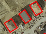 |
The Building Detection Benchmark contains the rectangular footprints of 665 buildings in 9 aerial or satellite images taken from Budapest, Szada (both in Hungary), Manchester (UK), Bodensee (Germany), Normandy and Cot d'Azur (both in France). Copyright: MTA SZTAKI and INRIA Sophia-Antipolis. |
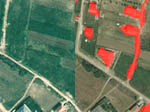 |
AirChange
Benchmark for change detection in optical aerial images
taken with several years time differences. 13 image pairs
of size 952x640 and resolution 1.5m/pixel. |
|
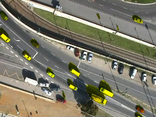
AirMotion
Benchmark for object motion detection in image pairs
captured by moving aerial vehicles. 83 image pairs (of size
320x240) with motion masks, from 3 different test sets captured
by flying balloons and airplanes
|