GeoComp demos
Research Group on Geo-Information Computing (GeoComp)
Demos on data processing of mobile and terrestrial mapping systems
|
|
 |
|
 |
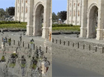
Topcon dataset: data interpretation and surface reconstruction from Topcon measurements. Distance measurement tool for Ladybug panoramic images. Data provided by Konasoft Ltd. 2013. |
Links
Geo-Information Computing @ Machine Perception Lab.
GeoComp Demos:
Contact
GeoComp Group leader: Dr. Csaba Benedek benedek.csaba@sztaki.hu
i4D project manager: Dr. Zsolt Jankó janko.zsolt@sztaki.hu
Head of MPLab: Prof. Tamás Szirányi
MPLab administration: Anikó Vágvölgyi
Address:
SZTAKIKende utca 13-17
H-1111 Budapest, Hungary Tel: +36 1 279 6194
Fax: +36 1 279 6292